Introduction to MCD06COSP_L3
MODIS (Aqua/Terra) COSP Cloud Properties Level 3 daily and monthly, 1x1 degree grid: Web Reference
Important: A newer, fixed version of MCD06COSP is available (2022 processing date and now tagged as Collection 6.2)
A code bug was discovered in mid 2021 in the COSP software, which caused a significant problem in the Low, Middle, and High aggregations of Cloud Fraction (from Cloud Mask). This problem was fixed in a new production run during the 2022 calendar year. Therefore, if any user has MCD06COSP data files with production dates in 2021 or earlier, they should obtain the new fixed MCD06COSP data files, with 2022 (or later) production dates, from LAADS. Because of these later production dates, fixed files will have a 2022 at the start of the second (last) date field (the production date field) of the filename. Also it was decided to roll the Collection version to 6.2 (062), even though the L2 inputs are still Collection 6.1 (061).
It should be noted that because the entire data record had to be reprocessed to correct the problem, this opportunity was taken to get feedback from high-level COSP data users on additions or changes that could be made to the files to make them more useful/powerful. Through this user feedback a number of additions were made to the file content during this rerun, including adding new parameters and new joint histograms.
A summary of the improvement included in this rerun is given below. Also see the updated v1.8 of the MCD06COSP User Guide available on the Documents page of this section
- Fixed the Low, Middle, High (LMH) aggregation of (Cloud Mask) Cloud Fraction (shown in purple highlight in Table 7 in Section 7.0)
- Added new Water Path parameters and new Water Path Joint Histograms (shown in green highlight in Table 7 in Section 7.0)
- Added a more complete listing of Partly Cloudy (PCL) parameters and statistics (shown in green highlight in Table 7 in Section 7.0)
- Modified (made more restrictive) the end point (terminators) in a number of Joint Histograms to better match the computed data domain of the input L2 parameters. Also slightly changed one interior bin boundary for Cloud Particle Size Liquid (See Section 7.0.1 for details)
L3 COSP Cloud Properties Product Introduction:
A new L3 COSP Cloud product (MCD06COSP) is now available. This product combines MODIS Terra (MOD06_L2) and MODIS Aqua (MYD06_L2) cloud mask, cloud top, and cloud optical retrieval data over daily and monthly timeframes, providing a set of custom cloud-related parameters, using specific dataset definitions, for better comparison with climate model output. This new dataset is provided in the Network Common Data Format Version 4 (NetCDF4) -- a data format widely used by the climate modeling community.
There are two L3 COSP Cloud products derived by combining two instrument / platform data streams (L2 MODIS Terra MOD06_L2 & L2 MODIS Aqua MYD06_L2) at two temporal timeframes (daily & monthly). L3 Daily COSP products are tagged D3, which is short for L3 Daily. L3 Monthly COSP products are tagged M3, which is short for L3 Monthly. That being said it's the Monthly (M3) COSP that will be primarily used by climate scientists and modelers.
The acronym MCD06COSP (used at the beginning of the L3 COSP filename) is a combination of the inputs to the product MOD06 + MYD06; and the output format COSP. To simplify the first part of the acronym, the letter C (that stands for combined platform) was substituted for the O (Terra platform) or A (Aqua platform) in the 2nd character position.
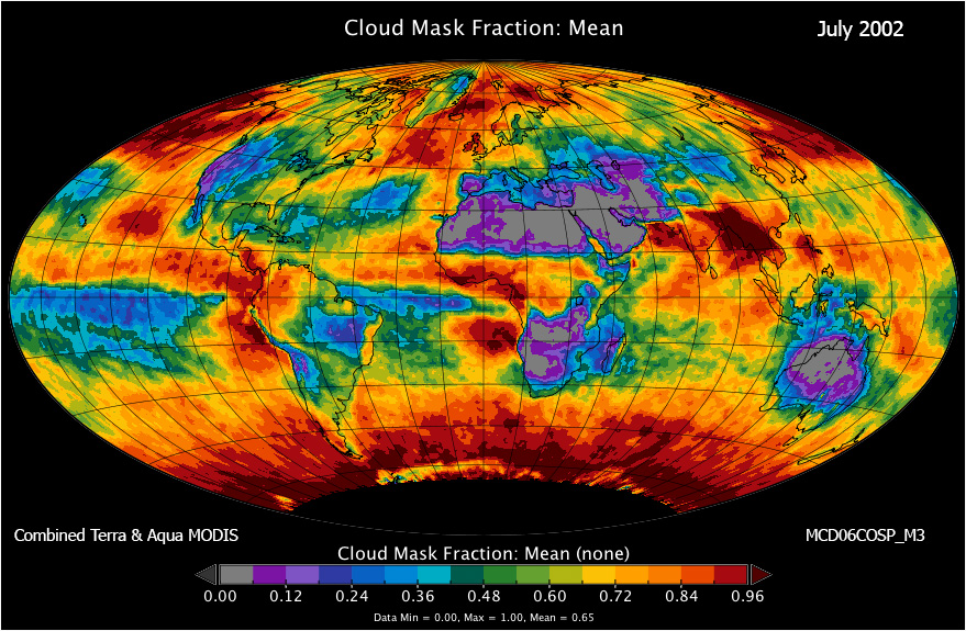
Given below is a sample NetCDF4 data file and a Cloud Mask Fraction image (combined Terra MODIS and Aqua MODIS) from the Monthly COSP product for July 2002.
Quick Note on Level-3 1x1 degree Gridding
Yori (the program that performs L3 COSP processing) "indicizes" the coordinates by the following equations: (lat + 90)/gridsize and (lon+180)/gridsize ... and rounding to the next closest integer, so index_lat >= (lat+90)/gridsize and index_lon >= (lon+180)/gridsize. For example a L2 pixel falling exactly on (89N 160W) would end up in the (179, 340) cell. In more general terms you could say that, given a lower (L) and and upper (U) limit of a grid cell, a coodinate x is in that cell if L < x <= U.
Download Sample NetCDF4 COSP file (July 2002).