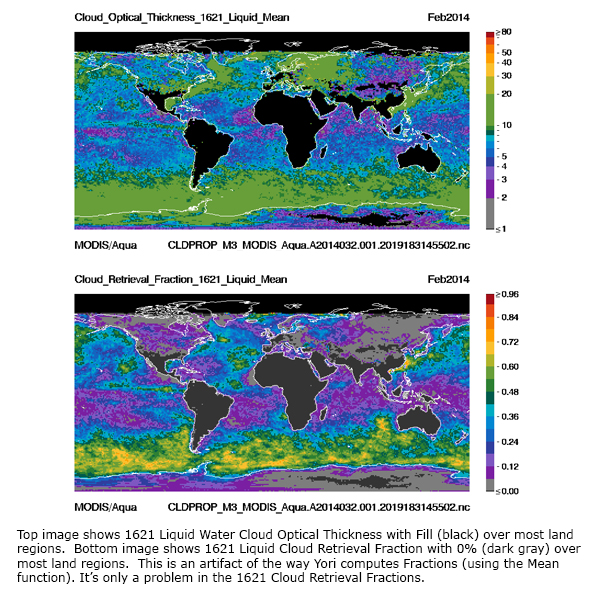
Tracking of known problems and subsequent fixes is an important issue for Continuity Atmosphere data users. This page will act as a repository of all known Continuity Atmosphere Data Product problems, as well as how to determine the problematic version (and the fixed version if available) of the NetCDF4 data -- therefore data users should check this page for updates regularly. Data Users unfamiliar with how to properly track problems and fixes by determining the version of their downloaded NetCDF4 files should refer to the documentation in the Introduction sublink (the top link along the LHS of this page).
Note that a checkmark (✔) in the tables below means Data Issue or Quality Statement applies. A blank means it's been fixed or does not apply.
L3 Cloud Properties (CLDPROP_L3) Data Issues: Table of Contents & Anchor Links (Note: Anchor Links point to a specific place within this page.)
| Collection/Platform where Issues Apply | ||||||
|---|---|---|---|---|---|---|
| Issue | Impact |
v1.1/MODIS |
v1.1/VIIRS |
v1.0/MODIS |
v1.0/VIIRS |
|
| #1. CRF 1621 shows 0% not fill over dry land |
L |
✔ |
✔ |
|
|
|
| #2. Degraded Geolocation required Reprocessing |
H |
|
✔ |
|
|
|
L3 Cloud Properties (CLDPROP_L3) Data Quality Statements: Table of Contents & Anchor Links (Note: Anchor Links point to a specific place within this page.)
| Collection/Platform where Quality Statements Apply | ||||||
|---|---|---|---|---|---|---|
| Quality Statement | Impact |
v1.1/MODIS |
v1.1/VIIRS |
v1.0/MODIS |
v1.0/VIIRS |
|
| #1. None Found Yet |
Q |
|
|
|
|
|
Issue #1: Cloud Retrieval Fraction 1621 shows 0% instead of fill over dry land
Description: Cloud Retrieval Fraction 1621 shows 0% fraction instead of fill over most dry land regions (land not covered with water, snow, or ice). Normally 0% cloud fractions are interpreted as clear sky, however for 1621 these 0% cloud fractions over much of the dry land portion of the Earth are actually non-retrieved data (false for clouds). This anomaly an artifact of how the Cloud Fractions are computed in Yori, the L3 processing system, using the Mean computation module. A fix for this issue has not been devised as of yet. Note that this issue only impacts the 1621 Cloud Fractions due to an unusual synergy between specific characteristics of the 1621 Retrieval (with no retrievals attempted over dry land) and the method used to compute fractions in Yori (using a True/False methodology). For all other retrieval algorithms: 21 (primary), 16, and 37 -- fill (missing) cloud optical property parameters (COP, CER, CWP) do in most cases correspond to clear sky (0% cloud fractions), so those are much easier to interpret. The exception would be for areas of nighttime and for missing data (orbital gaps), where both the standard cloud optical property parameters (COP, CER, CWP) and the cloud retrieval fractions (CRF) would show fill (missing).
PGE Versions & Production Dates of Problematic & Corrected Data:
Data Dates Affected: All data dates.
Affected Platform: Both instrument/platforms.
Versions Affected: Version 1.1

Issue #2: Degraded Geolocation for VIIRS SNPP data between 20 Dec 2019 and 6 Jan 2020 required reprocessing
 Description: SNPP VIIRS Continuity Atmosphere L2 and L3 products had degraded geolocation data during the indicated time period which warranted a reprocessing. Affected products have filenames that begin with AERDB, AERDT, CLDMSK, CLDPROP, and FSNRAD. (Note that FSNRAD is the L2 VIIRS and CrIS fusion product for SNPP and J1 (NOAA-20), where FSN stands for “fusion”.) Version 1.1 data during the indicated time period should be replaced by filenames with creation timestamps on or after January 8th 2020 (2020 008).
PGE Versions & Production Dates of Problematic & Corrected Data:
| Problematic Data | Corrected Data | ||
|---|---|---|---|
|
PGE Versions |
Production Dates |
PGE Versions |
Production Dates |
|
CLDPROP_D3 v1.1 |
< 2020 008 (01/08/20) |
CLDPROP_D3 v1.1 |
≥ 2020 008 (01/08/20) |
Data Dates Affected: 20 December 2019 (Day 354) through 6 Jan 2020 (Day 006)
Affected Platform: VIIRS SNPP
Versions Affected: Version.1.1
Quality Statement #1: None Found Yet
 Description: .
Guidance to Users:
Data Dates Affected:
Affected Platform:
Versions Affected:

