Tracking of known problems and subsequent fixes is an important issue for MODIS data users. This page will act as a repository of all known MODIS Atmosphere Data Product problems, as well as how to determine the problematic version (and the fixed version) of the HDF data -- therefore data users should check this page for updates regularly. Data Users unfamiliar with how to properly track problems and fixes by determining the version of their downloaded HDF files should refer to the documentation in the Introduction sublink (the top link along the LHS of this page).
Note that a checkmark (✔) in the tables below means Data Issue or Quality Statement applies. A blank means it's been fixed or does not apply.
Daily Data Issues: Table of Contents & Anchor Links
(Note: Anchor Links point to a specific place within this page.)
| Collection/Platform where Issues Apply | ||||||
|---|---|---|---|---|---|---|
| Issue | Impact |
C6.1/Terra |
C6.1/Aqua |
C6.0/Terra |
C6.0/Aqua |
|
| #1. Input L2 issues propagate downstream |
L |
✔ |
✔ |
✔ |
✔ |
|
| #2. CT Day Granules misplaced to Night |
L |
✔ |
✔ |
✔ |
✔ |
|
| #3. 1km CTP Low Ocean in December |
M |
|
|
✔ |
✔ |
|
| #4. Cloud Top Property pixel count discrepancies |
M |
✔ |
✔ |
|
|
|
Daily Data Quality Statements: Table of Contents & Anchor Links
(Note: Anchor Links point to a specific place within this page.)
| Collection/Platform where Quality Statements Apply | ||||||
|---|---|---|---|---|---|---|
| Quality Statement | Impact |
C6.1/Terra |
C6.1/Aqua |
C6.0/Terra |
C6.0/Aqua |
|
| #1. Missing Granules Aug 2017 |
Q |
✔ |
|
✔ |
|
|
| #2. Missing Granules Sep-Nov 2014 |
Q |
|
|
|
✔ |
|
| #3. Missing Pixel Count SDS for CTH |
Q |
✔ |
✔ |
✔ |
✔ |
|
 Issue #1: Problems in input Aerosol (04_L2), Water Vapor (05_L2), Cloud (06_L2), Atm. Profile (07_L2), and Cloud Mask (35_L2) propagate into downstream products
Description: See the Known Problem pages for the input (upstream) Level-2 products 04_L2 (Aerosol), 05_L2 (Water Vapor), 06_L2 (Cloud), 07_L2 (Profiles), and 35_L2 (Cloud Mask) by clicking on the links to the left. Users should make themselves aware of any issues in the upstream data products.
Data Dates Affected: Issues could occur for any date
Affected Platform: Terra and Aqua
Collections Affected: Issues possible in all Collections
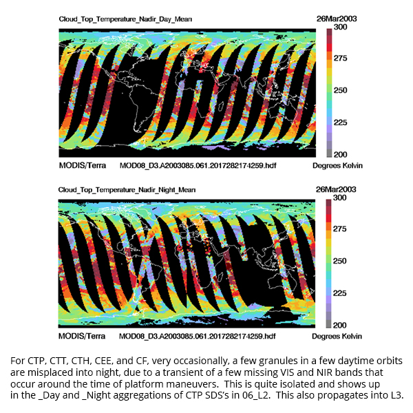
Issue #2: Very Intermittently occurring Cloud Top Property Granules misplaced from Daytime to Nighttime
 Description: Very occasionally, a few daytime granules are misplaced to the nighttime SDS's in 06_L2. This misplacement seems to be correlated with satellite maneuvers which occur for very brief periods (minutes) on a one to two month schedule. This problem is isolated to any 06_L2 SDS which has the suffix "_Day" or "_Night" (which corresponds to a few Cloud Top Property parameters). The upshot is for users reading any _Day SDS in L2, there will be a few isolated missing granules, and any user reading any _Night SDS in L2, there could be a few cases where day granules are overlapping the night granules. This is occurring in less than 0.001% of the time. To bypass this issue, users can read the un-aggregated L2 SDS's and do the D/N aggregation using the Cloud Mask D/N Flag if needed.
PGE Versions & Production Dates of Problematic & Corrected Data:
Data Dates Affected: Can occur anytime, but very intermittent and very limited in scope
Affected Platform: Aqua and Terra
Collections Affected: All Collections
Additional Documentation: View PDF (shows how this L2 error impact L3)
Issue #3: Problem in C6.0 1-km Cloud Top Pressure (Low) over Ocean in December
 Description: A bug was discovered in the Collection 6.0 1-km cloud top pressure low (low in the atmospheric layer, i.e. close to the Earth's Surface) over ocean algorithm for both Terra and Aqua. Low Atmosphere Cloud Top Pressure (> 600 hPa) retrievals for all oceanic L2 December data are not consistent with those of the other months and are considered to be incorrect. The impact will also be seen in daily, 8-day, and monthly L3 data, where 1km CTP data is ingested, Note that this issue was corrected in Collection 6.1 data.
PGE Versions & Production Dates of Problematic Data:
Data Dates Affected: Decembers from launch through 2016
Affected Platform: Aqua and Terra
Collections Affected: Collection 6.0 only
Issue #4: Cloud Top Property pixel count discrepancies
 Description: In July 2020, a data user found a few cases in the Collection 6.1 Daily (D3) product where the L3 pixel counts for Cloud_Fraction_Day were less than the L3 pixel counts for Cloud_Retrieval_Fraction_Combined, something that should never occur given the logical structure of the two source retrieval algorithms.
After an intensive investigation, it was discovered that the MODIS Standard 06_L2 Cloud Top Property Retrieval algorithm was, very intermittantly, producing fill (missing) data in regions where the Cloud Mask was valid and defined as cloudy -- meanwhile, in these same very limited regions, the Cloud Optical Property retrieval algorith was producing valid data.
Due to the fairly large grid size in Level-3 (1x1 degree), it was determined that these small areas of missing Level-2 data did not impact the gridded Level-3 mean (or mean fraction) values (e.g. Cloud_Fraction_Day) -- however, the pixel count values were impacted and pixel count differences are noticeable. This caused, in some very limted regions, the L3 gridded pixel count values for the parameter Cloud_Fraction_Day to be less than the pixel count values for Cloud_Retrieval_Fraction_Combined, which should never occur with bug-free source algorithms. (See Figure)
So to summarize, a code bug in the MODIS Standard 06_L2 Cloud Top Property retrieval algorithm is causing very intermittant missing Cloud Top Property related data and therefore any L3 derived parameters (such as Cloud_Fraction_Day) will show, in very limited spatial regions and temporal periods, fewer pixel counts than corresponding Cloud Optical Property related parameters (such as Cloud_Retrieval_Fraction_Combined). Users should note that the mean (or mean fraction) values are not visibly impacted – this bug only shows itself in the pixel count data. It is expected that this aforementioned Cloud Top Property retrieval algorithm bug will be corrected in Collection 7, with an expected release date in the 2021/2022 timeframe.
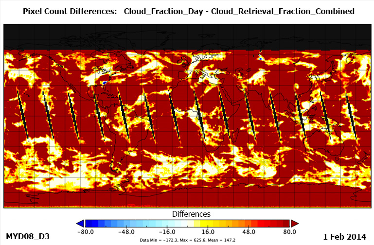
Figure. A depiction of the pixel count differences (Cloud_Fraction_Day – Cloud_Retrieval_Fraction_Combined) in the MYD08_D3 file for 1 Feb 2014. The blue color on the image (corresponding to negative difference values) shows regions (Georgia coast and Central Russia) impacted by the Cloud Top Property bug for this particular day, where intermittent missing values produced lower pixel counts of Cloud_Fraction_Day. It should be noted that the actual mean or mean fraction values did not show any visible impact, only the pixel count statistic showed visible impact.
PGE Versions & Production Dates of Problematic Data:
Data Dates Affected: Can occur anytime, but very intermittent and very limited in scope
Affected Platform: Aqua and Terra
Collections Affected: Collection 6.1 only
 Quality Statement #1: Missing Terra Data Granules/Orbits between 5 Aug 2017 and 6 Aug 2017
Description: Following the Terra Deep Space Calibration on August 5th, 2017 (2017 217) there were some faulty C6 Terra MODIS Atmosphere data as the focal plane temperatures did not return to nominal values until the day after - August 6th, 2017 (2017 218) 1420 UTC. So the granules for the time period between 2017 217 23:00 UTC and 2017 218 14:15 UTC were removed before the downstream Atmosphere processing. Data users will notice missing MODIS Atmosphere Data during this period for all Level-2 (L2) and Level-3 (L3) Daily atmosphere products.
Here is a sample L3 animation of Scattering Angle for 6 Aug 2017, which shows the missing data issue fairly clearly. The animation loops between the C6.0 data and the C6.1 data. The C6.1 data is improved showing less missing data, however a gap still exists in C6.1
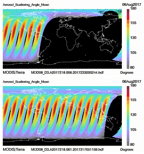
C6.0 vs C6.1 comparison of missing data gap (slight improvement shown in C6.1)
Data Dates Affected: Note there will be Missing Terra Data between 2017 217 (5 Aug 2017) at 23:00 UTC and 2017 218 (6 Aug 2017) at 14:15 UTC for all MODIS Atmosphere L2 and L3 Daily products.
Affected Platform: Terra Only
Collections Affected: Collection 6.0 and Collection 6.1 (some improvement noted in C6.1)
 Quality Statement #2: Missing Aqua Data Granules/Orbits between 9 Sep 2014 and 20 Nov 2014
Description: Incorrect production rules in MODAPS caused the initial release of Aqua MOD08_D3 data to be missing some granules/orbits in the September to November 2014 time period. Data was rerun and new corrected files are now available for download. Since a picture is worth a thousand words, an example animation showing this problem (before and after correction) is displayed below. Just to clarify, this was not a software/code bug, but instead a problem in the operational production rules.
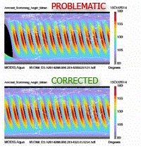
PGE Versions & Production Dates of Problematic & Corrected Data:
| Problematic Data | Corrected Data | ||
|---|---|---|---|
|
PGE Versions |
Production Dates |
PGE Versions |
Production Dates |
|
≤ PGE56 v6.1.5 |
≤ 2014 252 (9/9/2014) |
≥ PGE56 v6.1.9 |
≥ 2014 324 (11/20/2014) |
Data Dates Affected: 9 September 2014 to 20 November 2014
Affected Platform: Aqua Only
Collections Affected: Collection 6.0
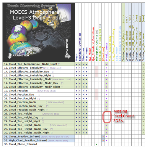
 Quality Statement #3: Pixel Count SDS not defined for Cloud Top Height (CTH)
Description: : In D3, E3, and M3, the Pixel Count SDSs for the full swath Cloud Top Height (CTH) are not defined (i.e., are missing); note that the Pixel Count SDSs are defined for the Nadir CTH scalar SDSs (see the figure below). This was an oversight in C6/C6.1 development, and breaks the “SDS inventory symmetry” in L3 where all other Cloud Top Property related parameters have Pixel Count SDSs defined. However, the missing CTH Pixel Count SDSs are not particularly problematic since users can indirectly obtain these counts from the CTH Joint Histograms. The upper bin of 18,000 meters does capture all the L2 CTH retrieval data since the algorithm caps output at 18000 meters (59,055 ft). This oversight is expected to be remedied in future Collections.
Data Dates Affected: All Data Dates
Affected Platform: Terra and Aqua
Collections Affected: Collection 6.0 and Collection 6.1

