

![]() Recently, the Atmosphere Group focus has expanded to develop "Continuity Products" allowing MODIS-like cloud and aerosol retrievals through the advancement of algorithms that can ingest remotely sensed data from a wider variety of instrument/platform combinations (where the sensor possesses a minimum set of common spectral channels) including VIIRS/SNPP, MODIS/AQUA, VIIRS/NOAA20, etc. This effort utilizes a shared-core architecture that takes retrieval method out of the equation when instrument inter-comparisons are made.
Recently, the Atmosphere Group focus has expanded to develop "Continuity Products" allowing MODIS-like cloud and aerosol retrievals through the advancement of algorithms that can ingest remotely sensed data from a wider variety of instrument/platform combinations (where the sensor possesses a minimum set of common spectral channels) including VIIRS/SNPP, MODIS/AQUA, VIIRS/NOAA20, etc. This effort utilizes a shared-core architecture that takes retrieval method out of the equation when instrument inter-comparisons are made.
There are five "shared core" Continuity Atmosphere products currently produced from various instruments and satellite platforms. Three of these are Level-2 or L2 Orbital Swath products: CLDMSK_L2, CLDPROP_L2, & AERDB_L2. Two of these are Level-3 or L3 Global Gridded products: CLDPROP_L3 & AERDB_L3. Each of the L3 products are produced at both Daily (D3) and Monthly (M3) temporal scales. In production currently for CLDMSK and CLDPROP are data from two instrument/platform combinations: VIIRS/SNPP & MODIS/AQUA. For AERDB, only VIIRS/SNPP data is being run. In the future, more instrument/platform combinations will be added. Each product is assigned an Earth Science Data Type name (specified below), which is used as the prefix in the NetCDF4 filename as well as for cataloging and archiving the datasets. The L2 and L3 Continuity Atmosphere products are:
Cloud
L2 Cloud Mask (CLDMSK_L2)
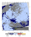
The L2 Continuity Cloud Mask Product indicates whether a given instrument field of view (FOV) of the Earth's surface is unobstructed by clouds or affected by cloud shadows. The cloud mask also provides additional information about the field of view (FOV) including the presence of: cirrus clouds, ice/snow, and sunglint contamination. Finally, flags denoting day/night and land/water are included. In production currently for CLDMSK are data from two instrument/platform combinations: VIIRS/SNPP & MODIS/AQUA. The retrieved Level 2 data are produced at the spatial resolution of 750x750 m (for VIIRS, at nadir) and 1x1 km (for MODIS, at nadir). The Full ESDT names are outlined at the bottom of this page.
L2 Cloud Properties (CLDPROP_L2)
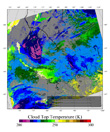
The L2 Continuity Cloud Properties Product monitors the physical and radiative properties of clouds including cloud particle phase (ice vs. liquid water clouds), effective cloud particle radius, cloud optical thickness, cloud shadow effects, cloud top temperature / pressure / height, cloud effective emissivity, cloud phase (ice vs. liquid water, opaque vs. non-opaque), and cloud fraction for both daytime and nighttime conditions. In production currently for CLDPROP are data from two instrument/platform combinations: VIIRS/SNPP & MODIS/AQUA. The retrieved Level 2 data are produced at the spatial resolution of 750x750 m (for VIIRS, at nadir) and 1x1 km (for MODIS, at nadir).The Full ESDT names are outlined at the bottom of this page.
L3 Cloud Properties (CLDPROP_D3 & CLDPROP_M3)
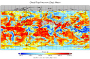
The L3 Continuity Cloud Properties Product contains roughly 600 statistical datasets derived from L2 Continuity Cloud Properties & L2 Continuity Cloud Mask products that are summarized over daily and monthly time periods. In production currently for CLDPROP are data from two instrument/platform combinations: VIIRS/SNPP & MODIS/AQUA. The Level 3 data are produced at the spatial resolution of 1x1 degree for both VIIRS and MODIS. The Full ESDT names are outlined at the bottom of this page.
Aerosol
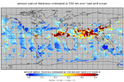
L2 Aerosol Deep Blue (AERDB_L2)
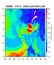
The L2 Continuity Aerosol Deep Blue Product monitors the global (except for over ice and snow) ambient aerosol optical thickness (AOT; also known as aerosol optical depth, AOD) for non-cloudy conditions during daytime. Aerosol parameters are derived using the Deep Blue Aerosol retrieval algorithm. In production currently for AERDB, only VIIRS/SNPP data is being run. The primary Level 2 data (retrieved along the orbit) are produced at the spatial resolution of a 6x6 km (for VIIRS, at nadir). In the future, it is expected that more instrument/platform combinations will be added. The Full ESDT names are outlined at the bottom of this page.
L3 Aerosol Deep Blue (AERDB_D3 & AERDB_M3)
The L3 Continuity Aerosol Deep Blue Product (currently in development) will contain roughly 100 statistical datasets derived from L2 Continuity Aerosol Deep Blue product that are summarized over daily and monthly time periods. In production currently for AERDB, only VIIRS/SNPP data is being run. The Level 3 data are produced at the spatial resolution of 1x1 degree for VIIRS. In the future, it is expected that more instrument/platform combinations will be added. The Full ESDT names are outlined at the bottom of this page.
Filename Format of Continuity Atmosphere Products
Note that for the filename sample shown below:
- The first part of the new standardized Product Prefix will be the Product Type (CLDMSK, CLDPROP, AERDB, or AERDT)
- The second part will be the Level (L2, D3, or M3)
- The third part will be the Instrument (VIIRS or MODIS)
- The fourth part will be the Satellite Platform (SNPP or AQUA)
- The DDD in the date denotes the Day of Year (001-366)
- All times are UTC time, not local time