

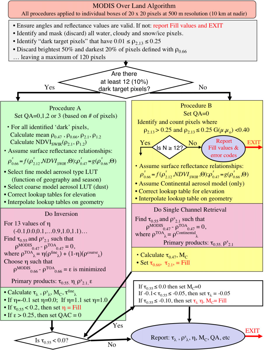
Aerosol Algorithm
Quantitative aerosol retrieval from space grew out of the need for atmospheric correction, that is the process of removing atmospheric effects on satellite remote sensing of earth's surface. Important satellite measures of land surface vegetation and ocean color were confused because of changing aerosol above the scene. The physical concept is that over "dark" surfaces (vegetated land and dark ocean), aerosol appears to brighten the scene, and the by-product of atmospheric correction is the retrieval of aerosol properties. As the scientific community became interested in quantifying the aerosol (e.g. for climate purposes), the dark target concept was refined. This website description is intended to be a synopsis of the retrieval algorithms as currently operational on the MODIS satellite instrument. These algorithms were originally pioneered and developed by Didier Tanre (Tanre et al., (1997)) and Yoram Kaufman (Kaufman et al., (1997)).
There are two separate and distinct “Dark Target” (DT) algorithms. The first one is used for retrieving aerosol information over ocean (dark in visible and longer wavelengths) and the second one over vegetated/dark-soiled land (dark in the visible).
In theory, these algorithms can be applied to any sensor that measures reflectance in appropriate wavelength bands covering visible (VIS), near-IR (NIR) and shortwave-IR (SWIR). Therefore, it is being modified to use on VIIRS observations as well.
The algorithm section of the site gives an overview of the retrieval algorithm and steps common to the land and ocean algorithm.
This website description is intended to be a synopsis of the algorithm; for more details, refer to the MOD04 ATBD, Levy et al. 2013 and Remer et al., 2013
As applied to MODIS, the standard dark Target aerosol product is 10 x 10 km at nadir that expands roughly four-fold towards the edges of the swath.
![]()
This aerosol product is labeled Level 2. For Collection 6, a new product is available which has a 3 x 3 km resolution at nadir. Although minor adjustments are made to accommodate the smaller pixel size, the fundamentals of the algorithm remain the same. The land and ocean algorithm subsections will describe the algorithms for the 10 km product, and the 3 km section will describe the necessary modifications.
Inputs and Preprocessing
Both the land and ocean aerosol algorithms rely on calibrated, geolocated reflectances (known as ‘Level 1B’ or ‘L1B’) provided by the MODIS Characterization Support Team (MCST). These are identified as products MOD02 and MOD03 for Terra and MYD02 and MYD03 for Aqua. Note that since the Terra satellite has the longer historical record from here onward our description of the algorithm will refer to the Terra "MOD" files but all Aqua files and products use "MYD" in the file or product name.
The algorithm actually uses L1B reflectances at three resolutions (MOD021KM, MOD02HKM and MOD02QKM for 1 km, 500 m and 250 m resolution channels, respectively). In addition, the MODIS algorithm uses the processed geophysical product (known as ‘Level 2’ or "L2 for short) MOD35 Wisconsin cloud mask product (Ackerman et al. 1998). Finally, the algorithm expects ancillary data from NCEP (National Center for Environmental Prediction) analyses, including the (closest to granule time) GDAS1 1°x1° 6 hourly meteorological analysis for water vapor, wind speed and ozone profiles. In past versions of the product the TOVS (before 2005) or the TOAST (after 2005) 1°x1° daily ozone analysis were used as inputs. Although the algorithm inputs NCEP data, when it is not available at the time of processing climatological data from NCEP is used for first guess water vapor, wind speeds,and ozone profiles.
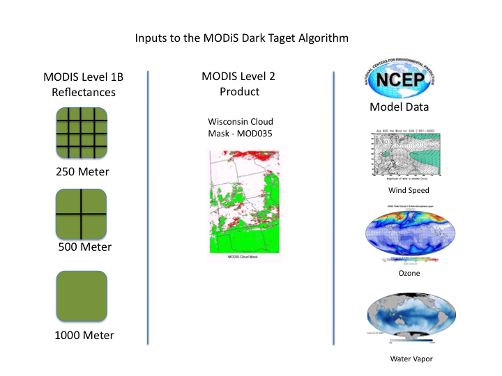
The aerosol algorithm reads in the required L1B, L2 and ancillary data into memory. Specifically, for the 10 km retrieval, it reads one scan line at a time, where each scan is made up of ten 1km pixels along track. The 1354 swath pixels are also collected into ten pixel boxes, so that there are 135 ’10 km’ boxes in a swath. Each of these boxes is separately considered for aerosol retrieval.
Both the land and ocean aerosol algorithms rely on calibrated, geolocated reflectances (known as ‘Level 1B’ or ‘L1B’) provided by the MODIS Characterization Support Team (MCST). These are identified as products MOD02 and MOD03 for Terra and MYD02 and MYD03 for Aqua. Note that since the Terra satellite has the longer historical record from here onward our description of the algorithm will refer to the Terra "MOD" files but all Aqua files and products use "MYD" in the file or product name.
The algorithm actually uses L1B reflectances at three resolutions (MOD021KM, MOD02HKM and MOD02QKM for 1 km, 500 m and 250 m resolution channels, respectively). In addition, the MODIS algorithm uses the processed geophysical product (known as ‘Level 2’ or "L2 for short) MOD35 Wisconsin cloud mask product (Ackerman et al. 1998). Finally, the algorithm expects ancillary data from NCEP (National Center for Environmental Prediction) analyses, including the (closest to granule time) GDAS1 1°x1° 6 hourly meteorological analysis for water vapor, wind speed and ozone profiles. In past versions of the product the TOVS (before 2005) or the TOAST (after 2005) 1°x1° daily ozone analysis were used as inputs. Although the algorithm inputs NCEP data, when it is not available at the time of processing climatological data from NCEP is used for first guess water vapor, wind speeds,and ozone profiles.
Aerosol over Ocean Algorithm
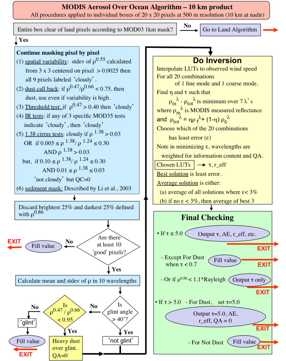
The history, theory and strategy of the aerosol retrieval over the ocean is described in in Tanré et al., (1997), Levy et al., (2003), Remer et al., (2005) and the C6 updates are described in Levy et al. (2013). The mechanics of the ocean algorithm are shown in the flowchart below. The algorithm is based on a ‘look-up table’ (LUT) approach, i.e., radiative transfer calculations are pre-computed for a set of aerosol and surface parameters and compared with the observed radiation field. The algorithm assumes that one fine and one coarse lognormal aerosol modes can be combined with proper weightings to represent the ambient aerosol properties over the target. Spectral reflectance from the LUT is compared with MODIS-measured spectral reflectance to find the ‘best’ (least-squares) fit. This best fit, or an ‘average’ of a set of the best fits is the solution to the inversion.
Below is a flow chart of the MODIS dark target ocean algorithm for the 10 Km product. The algorithm is also explained below the flow chart in text which is largely excerpted from the MODIS Algorithm Theoretical Basis Document (ATBD).
Aerosol over Land Algorithm
The goal of the land algorithm is to use the lookup table to determine the conditions that best mimic the MODIS-observed spectral reflectance, and retrieve the associated aerosol properties (including AOD [τ] and fine aerosol weighting [η]). The difficulty lies in making the most appropriate assumptions about both the surface and atmospheric contributions. The mechanics of the land algorithm are shown in the flowchart below.
The land algorithm retrieves aerosol properties in three channels simultaneously (the two visible channels, plus the 2.12 µm channel) and assumes that the 2.12 µm channel contains information about coarse mode aerosol as well as the surface reflectance. The surface reflectance in the visible is a function of the surface reflectance at 2.12 µm, and a function of the scattering angle and the “greenness” of the surface in the mid-IR spectrum (NDVI-like parameter based on 1.24 µm and 2.12 µm channels).
Like the ocean algorithm, the land algorithm is an inversion, but takes only three (nearly) independent observations of spectral reflectance (0.47, 0.65 and 2.1 µm) to retrieve three (nearly) independent pieces of information. These include total t at 0.55 µm (τ 0.55), Fine (model) Weighting at 0.55 µm (η 0.55 ), and the surface reflectance at 2.1 µm (ρs2.12). The land algorithm is based on look-up table (LUT) approach, i.e., radiative transfer calculations are pre-computed for a set of aerosol and surface parameters and compared with the observed radiation field. The algorithm assumes that one fine-dominated aerosol model and one coarse-dominated aerosol model (each may be comprised of multiple lognormal modes) can be combined with proper weightings to represent the ambient aerosol properties over the target. Spectral reflectance from the LUT is compared with MODIS-measured spectral reflectance to find the best match. This best fit is the solution to the inversion.
The Deep Blue Aerosol Algorithm
Deep Blue is an algorithm used to calculate aerosol optical depth (AOD) and Ångström Exponent (α or AE) over land using data from the aforementioned satellite instruments. By making use of measurements at different wavelengths, with different contrast between surface and atmospheric features, Deep Blue estimates AOD. This process is known as a 'retrieval'. At many wavelengths of visible light, the contrast between aerosols and the surface is difficult to discern, but in the 412 nm band, aerosol signals tend to be bright and surface features dark. The 412 nm band is sometimes referred to as the "deep blue" band, from which the algorithm gets its name. AOD retrieval in the 412 nm band allows for increased spatial coverage relative to tthe Dark Target algorithm, which makes different assumptions which are not valid over bright surfaces such as deserts.
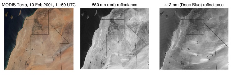
[True color, red band, and deep blue band images for a MODIS scene over the Saharan coast.]
Shown here is a true color image from MODIS Terra. Center, the same area viewed using a 650 nm (red) band. On the right, the same area viewed using a 412 nm (Deep Blue) band. Aerosol features stand out more strongly in the Deep Blue band than the red band.
Over land, Deep Blue uses different bands for bright land (primarily 412, 470/490 nm) and dark land (primarily 470/490, 650 nm). Over water, the Deep Blue algorithm is not used. However, Deep Blue data sets also contain aerosol data over oceans, derived from a different algorithm, based on a multispectral inversion approach. Some of the solar bands measured by these instruments are illustrated below; note that MODIS and VIIRS possess additional bands not shown.
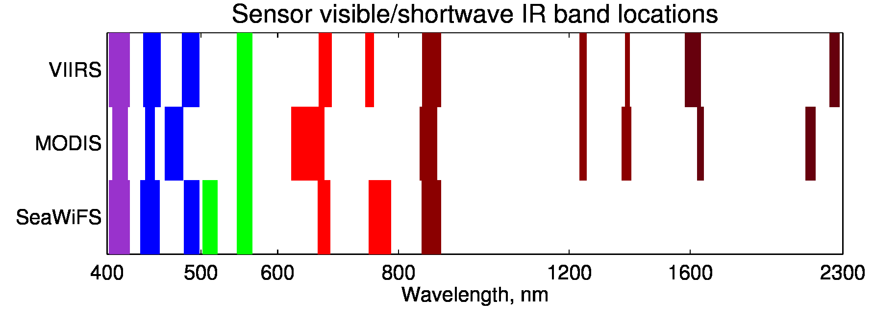
[Wavelengths at which VIIRS, MODIS, and SeaWiFS measure.]
The VIIRS, MODIS, and SeaWiFS instruments all measure light at multiple wavelengths. As they observe at similar wavelengths, Deep Blue can use similar techniques to monitor aerosols with all of them.