L3 CLDPROP COSP Product Information
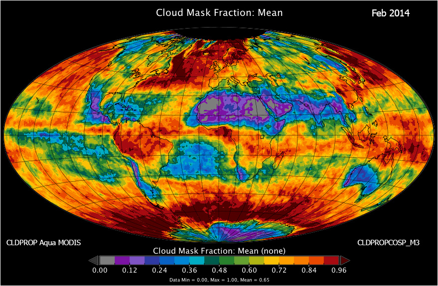
A new L3 CLDPROP COSP product (CLDPROPCOSP) is now available. This product contains either MODIS Aqua (CLDPROP_L2_MODIS_Aqua) or VIIRS SNPP (CLDPROP_L3_VIIRS_SNPP) or VIIRS NOAA20 (CLDPROP_L3_VIIRS_NOAA20) cloud mask, cloud top, and cloud optical retrieval data over daily and monthly timeframes, providing a set of custom cloud-related parameters, using specific dataset definitions, for better comparison with climate model output. This new dataset is provided in the Network Common Data Format Version 4 (NetCDF4) -- a data format widely used by the climate modeling community. There are three L3 COSP Cloud products derived from three instrument / platform data streams (MODIS Aqua, VIIRS SNPP, or VIIRS NOAA20) at two temporal timeframes (daily & monthly). L3 Daily COSP products are tagged D3, which is short for L3 Daily. L3 Monthly COSP products are tagged M3, which is short for L3 Monthly. That being said it's the Monthly (M3) COSP that will be primarily used by climate scientists and modelers. The acronym CLDPROPCOSP (used at the beginning of the L3 COSP filename) is a combination of the inputs to the product CLDPROP; and the output format COSP. Given below is a Cloud Mask Fraction image (Aqua MODIS) from the Monthly CLDPROP COSP product for February 2014.
Quick Note on Level-3 1x1 degree Gridding
Yori (the program that performs L3 Continuity processing) "indicizes" the coordinates by the following equations: (lat + 90)/gridsize and (lon+180)/gridsize ... and rounding to the next closest integer, so index_lat >= (lat+90)/gridsize and index_lon >= (lon+180)/gridsize. For example a L2 pixel falling exactly on (89N 160W) would end up in the (179, 340) cell. In more general terms you could say that, given a lower (L) and and upper (U) limit of a grid cell, a coodinate x is in that cell if L < x <= U.
Download Sample NetCDF4 Continuity MODIS Aqua COSP file (Feb 2014).