

Tracking of known problems and subsequent fixes is an important issue for MODIS data users. This page will act as a repository of all known MODIS Atmosphere Data Product problems, as well as how to determine the problematic version (and the fixed version) of the HDF data -- therefore data users should check this page for updates regularly. Data Users unfamiliar with how to properly track problems and fixes by determining the version of their downloaded HDF files should refer to the documentation in the Introduction sublink (the top link along the LHS of this page).
Note that a checkmark (✔) in the tables below means Data Issue or Quality Statement applies. A blank means it's been fixed or does not apply.
Atmosphere Profile Data Issues: Table of Contents & Anchor Links
(Note: Anchor Links point to a specific place within this page.)
| Collection/Platform where Issues Apply | ||||||
|---|---|---|---|---|---|---|
| Issue | Impact |
C6.1/Terra |
C6.1/Aqua |
C6.0/Terra |
C6.0/Aqua |
|
| #1. Bad Terra IR WV Profiles (Band 27) |
H |
✔ |
|
|||
| #2. Unstable Antarctica Profiles |
L |
|
✔ |
|||
| #3. Suspect Nighttime IR WV |
M |
|
✔ |
|||
| #4. GDAS update causes slight changes |
L |
|
✔ |
|||
Issue #1: Incorrect Terra IR Water Vapor Profiles from Band 27 Crosstalk
 Description: In the month of April 2016, this update was received from the PGE03 (Atm Profile / Cloud Mask) developers: A band 27 cross-talk problem (in Terra only) that started around the year 2010 and became more pronounced over time, produced incorrect IR Water Vapor profiles with artificially low moisture content in the middle atmospheric layer and excessively high values in the upper troposphere. The MODIS Calibration Support Team (MCST) is still investigating possible fixes for this problem. The IR Water Vapor profile data is in an SDS called "Water_Vapor_Infrared" in the 05_L2 (Water Vapor Product) file. Note that this is a duplicate of the same SDS in the 07_L2 (Atm Profiles Product). Finally, note that the alternate Water Vapor parameter based on NIR bands: "Water_Vapor_Near_Infrared", which is only in the 05_L2 (Water Vapor Product) file, is not affected by this problem.
PGE Versions & Production Dates of Problematic & Corrected Data:
| Problematic Data | Corrected Data | ||
|---|---|---|---|
|
PGE Versions |
Production Dates |
PGE Versions |
Production Dates |
|
C6.0 PGE03 (All Versions) |
≥ 2010 001 (01/01/2010) |
Corrected in C6.1 |
Corrected in C6.1 |
Data Dates Affected: ≥ January 2010 (but worse ≥ 2014)
Affected Platform: Terra Only
Collections Affected: Collection 6.0 (Fixed in Collection 6.1)
Issue #2: Unstable Atmospheric Profile Retrievals over Antarctica
 Description:In collection 006, the cloud mask is failing to detect high thick clouds over the Weddell Sea area when it is ice-covered. This represents a small area over very dry conditions, but it is causing high and noisy retrievals (high standard deviation) in the integrated water vapor values (440-10 hPa) and unrealistic values in the Retrieved Temperature Profiles and Total Ozone. These problem pixels can be filtered out by users with additional sanity checks until it is fixed in the future PGE03 delivery.
PGE Versions & Production Dates of Problematic & Corrected Data:
| Problematic Data | Corrected Data | ||
|---|---|---|---|
|
PGE Versions |
Production Dates |
PGE Versions |
Production Dates |
|
≤ PGE03 v6.0.40 |
All |
Not Corrected |
Not Corrected |
Data Dates Affected: ≥ July 2002
Affected Platform: Aqua Only
Collections Affected: Collection 6.0
Issue #3: Suspect Infrared (IR) Water Vapor Data at Night
 Description: It should noted that the Infrared (IR) Water Vapor Data is copied from 07_L2 into 05_L2. There was a problem in the Collection 6 (C6) Atmosphere Profile Product (07_L2) for nighttime data only. In the nighttime (07_L2) granules, an error occurred in selecting the proper GDAS (NCEP 1-Degree Global Data Assimilation Model) re-analyses ancillary data file. Instead of selecting the file closest in time with a less than 3 hour time differences between the GDAS time and the granule time, the algorithm selected the wrong GDAS file time resulting in as much as a 6 hour time difference. The 07_L2 algorithm uses the surface pressure variable of the GDAS reanalyses to determine the lowest level of the atmospheric temperature, moisture, and ozone profiles. To set the lowest level as accurate as possible is very important for integrating the water vapor content of the column and the layer mean of water vapor close to the surface. The error affected the 07 L2 SDS's "Water_Vapor" and "Water_Vapor_Low". The values were just "marginally off" but affected all granules globally. Since the Infrared (IR) Water Vapor Data data is copied from 07_L2 into 05_L2 HDF files, both the 05_L2 and 07_L2 HDF data products were affected.
PGE Versions & Production Dates of Problematic & Corrected Data:
| Problematic Data | Corrected Data | ||
|---|---|---|---|
|
PGE Versions |
Production Dates |
PGE Versions |
Production Dates |
|
C6.0 ≤ PGE04 v6.0.37 |
≤ 2014 191 (07/10/2014) |
C6.0 ≥ PGE04 v6.0.38 |
≥ 2014 195 (07/14/2014) |
Data Dates Affected: July 2002 to July 2014 (Nighttime Granules only)
Affected Platform: Aqua Only
Collections Affected: Collection 006
Issue #4: New GDAS for data processed 12 June 2019 and forward
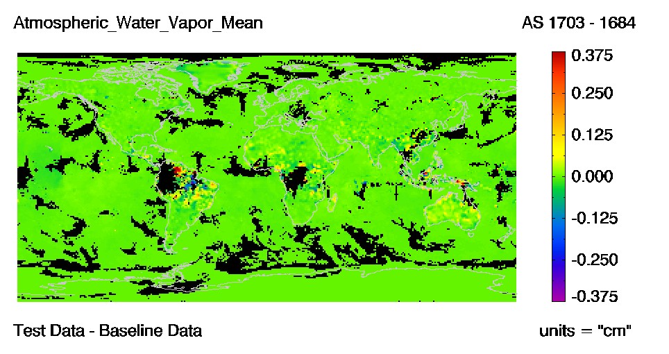
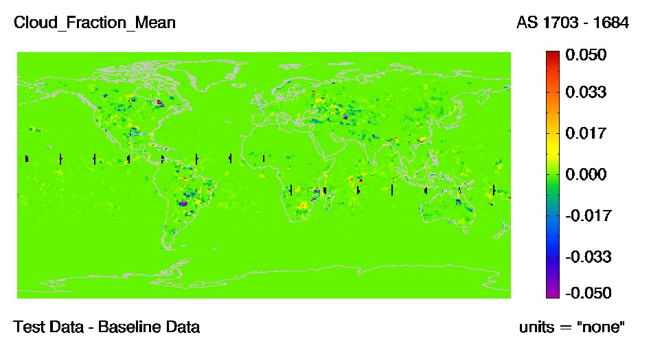
Description: A change has been made to the GDAS (Global Data Assimilation System) atmospheric profiles of temperature, moisture, and ozone profiles that are used as ancillary data in the cloud top properties algorithms (5-km and 1-km MOD06CT and MYD06CT products). The greatest impact to these products is seen in polar regions where many cloud top heights are raised (cloud top pressures lowered). A decrease is seen in the number of cloud height retrievals at surface levels due to errors in temperature profiles and uncertainties in the algorithms. Changes in other parts of the world appear to be random and mostly less than 50 hPa.
The MODIS cloud masks (MOD35 and MYD35) are minimally impacted through changes to the GDAS surface temperature. These cloud detection changes are small, random in nature, and are confined almost completely to nighttime data where surface temperatures are important for warmer surfaces.
Shown below is a difference image from Terra daily (MOD08_D3) for day 2019134. The test data used for this difference image was created using a new version of GDAS data and the baseline is the old version.
PGE Versions & Production Dates of Problematic Data:
Data Dates Affected: New GDAS Data was used to process starting on 12 June 2019 data.
Affected Platform: Terra & Aqua
Collections Affected: Collection 6.1 only
Additional Documentation: