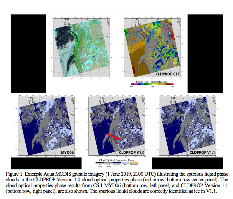
Tracking of known problems and subsequent fixes is an important issue for Continuity Atmosphere data users. This page will act as a repository of all known Continuity Atmosphere Data Product problems, as well as how to determine the problematic version (and the fixed version if available) of the NetCDF4 data -- therefore data users should check this page for updates regularly. Data Users unfamiliar with how to properly track problems and fixes by determining the version of their downloaded NetCDF4 files should refer to the documentation in the Introduction sublink (the top link along the LHS of this page).
Note that a checkmark (✔) in the tables below means Data Issue or Quality Statement applies. A blank means it's been fixed or does not apply.
L2 Cloud Properties (CLDPROP_L2) Data Issues: Table of Contents & Anchor Links
(Note: Anchor Links point to a specific place within this page.)
| Collection/Platform where Issues Apply | ||||||
|---|---|---|---|---|---|---|
| Issue | Impact |
v1.1/MODIS |
v1.1/VIIRS |
v1.0/MODIS |
v1.0/VIIRS |
|
| #1. Very Intermittant CER Liquid < 4.0 microns |
L |
|
|
✔ |
✔ |
|
| #2. Erroneous Liquid Cloud Phase Results |
H |
|
|
✔ |
✔ |
|
| #3. Degraded Geolocation required Reprocessing |
H |
|
✔ |
|
|
|
| #4. Ice LUT Fix & Missing CT granule edge retrievals |
M |
✔ |
✔ |
|
|
|
L2 Cloud Properties (CLDPROP_L2) Data Quality Statements: Table of Contents & Anchor Links
(Note: Anchor Links point to a specific place within this page.)
| Collection/Platform where Quality Statements Apply | ||||||
|---|---|---|---|---|---|---|
| Quality Statement | Impact | v1.1/MODIS | v1.1/MODIS | v1.0/MODIS | v1.0/VIIRS | Link |
| #1. None Found Yet |
Q |
|||||
Issue #1: Very Intermittantly Cloud Effective Radius Retrievals for Liquid Water Clouds drop below the expected minimum value of 4.0 microns
 Description: In a very small number of cases, the Cloud Effective Radius Retrievals for Liquid Water Clouds drop below the expected minimum value of 4.0 microns. In the Continuity Cloud Retrieval Algorithm, only the Alternate Solution Logic (ASL) cuts off at 4.0 microns explicitly. The main solution logic (and this is for all of CHIMAERA) cuts off on library_radii(1), which in the case of MODIS and VIIRS (and several other heads) is 2.0 microns. However, from selected case study results, this is a very rare event, occurring in less than 0.001% of cases. This is only an issue in v1.0 data.
PGE Versions & Production Dates of Problematic & Corrected Data:
| Problematic Data | Corrected Data | ||
|---|---|---|---|
|
PGE Versions |
Production Dates |
PGE Versions |
Production Dates |
|
CLDPROP_L2 v1.0 |
≤ 2019 001 (01/01/19) |
CLDPROP_L2 v1.1 |
All Dates Corrected |
Data Dates Affected: 1 March 2012 (Day 061) and forward (All Data Dates)
Affected Platform: MODIS AQUA and VIIRS SNPP
Versions Affected: Version.1.0
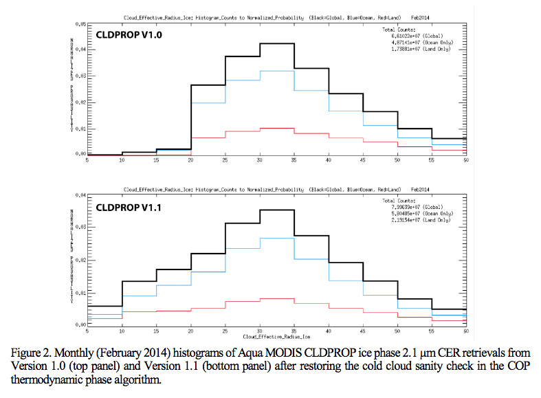
Issue #2: Erroneous Liquid Cloud Phase results
 Description: Issue with Cloud Optical Properties Thermodynamic Phase caused erroneous Liquid Cloud Phase results. This was identified with a striking discontinuity in the Marginal Histograms of Ice Cloud Effective Radius around 20 microns. This was corrected by restoring the Cold Cloud Sanity Check in the Cloud Optical Properties Thermodynamic Phase Algorithm.


PGE Versions & Production Dates of Problematic & Corrected Data:
| Problematic Data | Corrected Data | ||
|---|---|---|---|
|
PGE Versions |
Production Dates |
PGE Versions |
Production Dates |
|
CLDPROP_L2 v1.0 |
All Dates |
CLDPROP_L2 v1.1 |
All Dates Corrected |
Data Dates Affected: All Data Dates
Affected Platform: MODIS Aqua & VIIRS SNPP
Versions Affected: Version.1.0
Issue #3: Degraded Geolocation for VIIRS SNPP data between 20 Dec 2019 and 6 Jan 2020 required reprocessing
 Description: SNPP VIIRS Continuity Atmosphere L2 and L3 products had degraded geolocation data during the indicated time period which warranted a reprocessing. Affected products have filenames that begin with AERDB, AERDT, CLDMSK, CLDPROP, and FSNRAD. (Note that FSNRAD is the L2 VIIRS and CrIS fusion product for SNPP and J1 (NOAA-20), where FSN stands for “fusion”.) Version 1.1 data during the indicated time period should be replaced by filenames with creation timestamps on or after January 8th 2020 (2020 008).
PGE Versions & Production Dates of Problematic & Corrected Data:
| Problematic Data | Corrected Data | ||
|---|---|---|---|
|
PGE Versions |
Production Dates |
PGE Versions |
Production Dates |
|
CLDPROP_L2 v1.1 |
< 2020 008 (01/08/20) |
CLDPROP_L2 v1.1 |
≥ 2020 008 (01/08/20) |
Data Dates Affected: 20 December 2019 (Day 354) starting at 13:54:00 UTC and forward through 6 Jan 2020 (Day 006) ending at 13:53:59 UTC
Affected Platform: VIIRS SNPP
Versions Affected: Version.1.1
Issue #4: Ice LUT fix & Missing CT Retrievals near granule edge
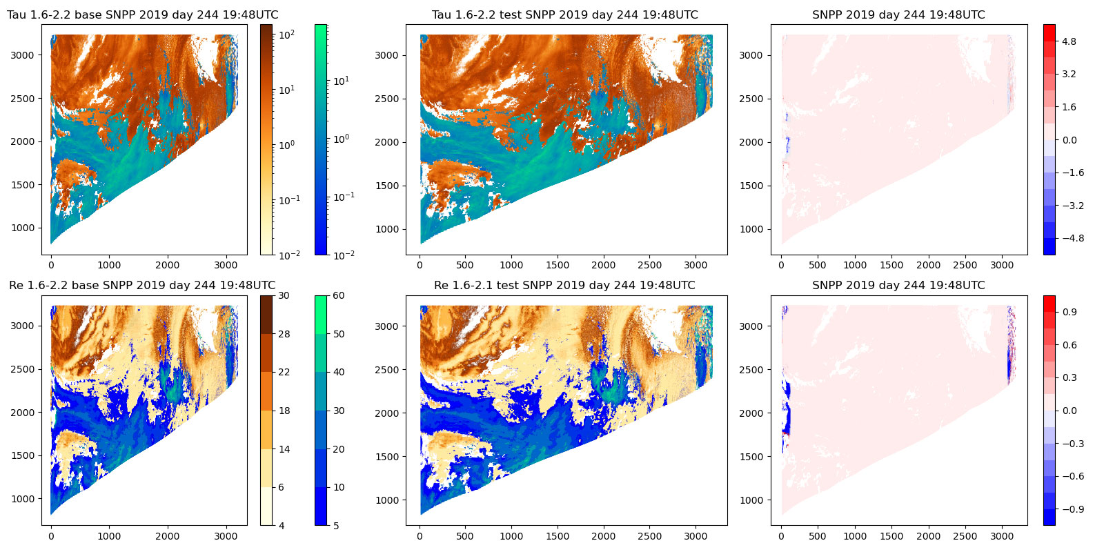
 Description: There are two issues to be fixed in the forward stream of CLDPROP_L2. The Ice Look-Up-Tables (LUTs) needed to be tweaked, this change needed to be implemented in both CLDPROP MODIS Aqua and CLDPROP VIIRS SNPP. This Ice LUT change only impacted the 1.6/2/1 retrievals for ice phase. That fix has been verified through test runs, although the NOAA20 test is pending. A more troublesome issue was a few pixels at the edge of VIIRS granules where Cloud Top retrievals are fill (missing), over a domain of up to 17 pixel columns, especially noticeable over the southern ocean This appears to correspond to view angles larger than 70 degrees.

Shown above is a difference image for a VIIRS granule that illustrates changes made to the code. There are two things to note. In the “base” image, you can see a thick line of liquid water retrievals visible at the left scan edge. It is not present in the “test” image. That line was due to CT not being present due to view angle going above 70 degrees. The other more prominent issue is the thicker stripe of changes in the difference image. That one is due to ice LUT getting corrected.
PGE Versions & Production Dates of Problematic & Corrected Data:
| Problematic Data | Corrected Data | ||
|---|---|---|---|
|
PGE Versions |
Production Dates |
PGE Versions |
Production Dates |
|
CLDPROP_L2 v1.1 |
< 2022 121 (05/01/22) |
CLDPROP_L2 v1.1 |
≥ 2022 121 (05/01/22) |
Data Dates Affected: From Launch forward through 30 Apr 2022
Affected Platform: VIIRS SNPP (both Ice LUT fix and missing CT retrievals) & MODIS Aqua (Ice LUT fix only)
Versions Affected: Version.1.1
Quality Statement #1: None Found Yet
 Description: .
Guidance to Users:
Data Dates Affected:
Affected Platform:
Versions Affected:

