Data issues
Water Vapor Data Issues


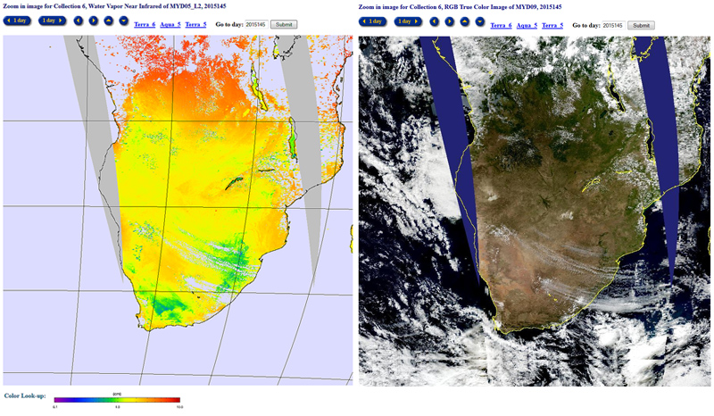
The Water Vapor Product monitors atmospheric water vapor and precipitable water. The ESDT names are MOD05_L2 (Terra) and MYD05_L2 (Aqua).
Water Vapor Data Issues
High Resolution Images generated from MOD05_L2
Algorithm Theoretical Basis Document
Offered below is the Algorithm Theoretical Basis Document for the MODIS Water Vapor (MOD05_L2) Product.
MODIS Atmosphere L2 Water Vapor Product
![]()
Dataset Short Name:
MOD05_L2 (Terra Platform)
MYD05_L2 (Aqua Platform)
Dataset Long Name:
MODIS/Terra Level-2 (L2) Water Vapor Product
MODIS/Aqua Level-2 (L2) Water Vapor Product
(Swath, 1km and 5km Resolution)
(5 minute time-period HDF files)
Water Vapor (05_L2) File Specification
(Common Data Language (CDL) Format)
 Water Vapor Product (05_L2) File Format Basics
Product Grid
The MODIS Water Vapor (MOD05_L2) product contains data that has a spatial resolution (pixel size) of 1 x 1 kilometers (at nadir) or 5 x 5 kilometers (at nadir). Each MOD05_L2 product file covers a five-minute time interval (based on the start time of each MODIS Level-1B granule), which means the MOD05_L2 output grid is 1350 1-km pixels in width and 2030 1-km pixels in length (or 270 by 406 5-km pixels) for nine consecutive granules. Every tenth granule has an output grid size of 1350 by 2040 pixels (or 270 by 408).
NIR Water Vapor Algorithm
MODIS is an instrument on the EOS polar orbiting satellite platforms designed to measure biological and physical processes on a global scale every 1 to 2 days. It is a 36-channel scanning radiometer covering the spectral region 0.4 - 15 µm . Five near-IR MODIS channels are useful for remote sensing of water vapor. The positions and widths of these channels are given in Table 1.